Laura Faye Tenenbaum is an Innovator in Science Communication and a member of the Earth Science Communications Team at NASA’s Jet Propulsion Laboratory, where she creates content for NASA’s Global Climate Change website and the “Earth Right Now” blog. She develops original videos and interactive new media products to engage and educate students, teachers, and professionals in climate and environmental science. Her team won two Webby Awards for Best Science Website. She also holds a faculty position in the Physical Science Department at Glendale Community College for the last 13 years.
Ms. Tenenbaum studied Marine Science at the University of California, Santa Cruz as both an undergraduate and graduate student. She lived in Southeast Asia during the 90’s and traveled extensively. Her goal is to bring science, multimedia and education together to attract a highly motivated and enthusiastic new generation that will be ready to take on the environmental challenges we face.

Laura hadn’t always intented on going into science. In fact, she thought that science was not for her. But things changed in her Junior year of college when she took an oceanography course. During that class an encounter with sea slugs of all things totally captivated her and Laura’s career path veered sharply toward the world of science.
Nowadays she is currently working at NASA on their project called Oceans Melting Greenland (OMG).
Oceans Melting Greenland
Global sea level rise will be one of the major environmental challenges of the 21st Century. Oceans Melting Greenland (OMG) will pave the way for improved estimates of sea level rise by addressing the question: To what extent are the oceans melting Greenland’s ice from below? Over a five-year campaign, OMG will observe changing water temperatures on the continental shelf surrounding Greenland, and how marine glaciers react to the presence of warm, salty Atlantic Water. The complicated geometry of the sea floor steers currents on the shelf and often determines whether Atlantic Water can reach into the long narrow fjords and interact with the coastal glaciers. Because knowledge of these pathways is a critical component of modeling the interaction between the oceans and ice sheet, OMG will facilitate improved measurements of the shape and depth of the sea floor in key regions as well.
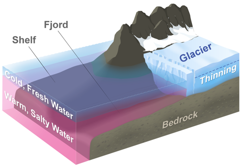
The diagram above represents a typical glacier in Greenland. Below the cold, fresh layer near the surface a layer of warm, salty water reaches into the fjords to melt the glacier’s edge. OMG will measure the volume and extent of this warm layer each year and relate it to thinning and retreat of the glaciers.
OMG will use NASA’s G-III to fly the Glacier and Ice Surface Topography Interferometer (GLISTIN-A) in order to generate high resolution, high precision elevation measurements of Greenland’s coastal glaciers during the spring. Annual surveys by GLISTIN will measure glacier thinning and retreat over the preceding season. A second aircraft campaign, also on the NASA G-III, will be occur each year in the summer to deploy 250 expendable temperature and salinity probes along the continental shelf to measure the volume, extent, of warm, salty Atlantic Water. These data, along with fundamental new and critical observations of airborne marine gravity and ship-based observations of the sea floor geometry will provide a revolutionary data set for modeling ocean/ice interactions and lead to improved estimates of global sea level rise.

